Ha Giang – Du Gia – Dong Van · 3 days, 2 nights
Suggested programme. Confirm timings, prices, accommodation and access before booking.
Owner-requested route reconstructed from the 28–30 October 2026 journey: riverside roads to Thái An and Du Già, Ngọc Long and Bản Án, then ĐT176, QL4C and Lũng Cú. Road alignment is map-matched; current passability and the final Bản Án approach need local confirmation.
View the full tour on the mapYour itinerary
Confirm an early departure and daylight arrival with the local guide. Suggested times in Vietnam time (UTC+7). The guide confirms timings and connecting roads when arranging the trip.
Added stops marked “—” have no scheduled arrival time. Extra stops and rough roads can extend the day; revise departure and return times with your guide.
Km0 → QL4C → Cát Lý → Thái An → TL181 → Du Già
- Km0 Hà Giang · start
Take the short city connection to QL4C, then the local riverside road toward Cát Lý.
- Cát Lý Camping
Follow the white riverside road shown in the supplied image; do not substitute the main highway.
- Thái An · white riverside road
Follow the white road through the supplied reference at 22.979078, 105.086432, then cross near Nam Lương and rejoin TL181. Confirm current bridge and road access locally.
- TL181 → road 176 → Du Già
Continue along TL181, then follow the road 176 bends to Du Già.
- Du Già · rest and overnight
Keep the requested first-night stop in Du Già.
Overnight: Du Già; accommodation to be confirmed.
Du Già → Ngọc Long → Bản Án → Mậu Duệ → Mèo Vạc → Đồng Văn
- Du Già · start toward Bản Án
Follow the small road east, passing the recorded “Chốt đo độ cồn” reference. That historical checkpoint is a route reference, not a permanent service or attraction.
- Dg xau 5 · recorded rough-road point
This is the owner-confirmed pin. Assess the current surface and riding difficulty; no numeric road score is inferred from the name.
- Ngọc Long
Keep following the small road through Ngọc Long toward Bản Án.
- Bản Án · village-road approach
The mapped road reaches the village approach. The photo pin is about 430 m away; confirm the final approach and any stream or walking access locally.
- Bản Án → Mậu Duệ · rejoin ĐT176
Follow the white village road past the next recorded view, then rejoin ĐT176 toward Mèo Vạc.
- ĐT176 → M-shaped road → Mèo Vạc
Use the existing road 176 corridor. Allow time for rough sections and rest stops.
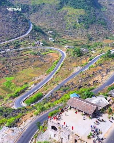 View stop and photo ↗
- QL4C → Mã Pí Lèng → Đồng Văn
Continue on QL4C to Đồng Văn. This is a long day; confirm a daylight schedule without changing the requested overnight stop.
Overnight: Đồng Văn; accommodation to be confirmed.
Đồng Văn → Lũng Cú → Yên Minh → Cán Tỷ → Quản Bạ → Km0
- Đồng Văn → Lũng Cú
Retain the owner-requested day 3 Lũng Cú visit.
- Return toward Yên Minh on QL4C
Return via the normal plateau road, keeping the route through Yên Minh.
- Yên Minh → Cán Tỷ · lone-tree road
Use the owner-confirmed Cán Tỷ lone-tree road. The QL4C pine-forest road remains available as an alternative in the map controls.
- Cán Tỷ → Quản Bạ → Km0
Rejoin QL4C and finish at Km0 Hà Giang.
After the final day, collect stored luggage and allow time before your onward bus. Hanoi sleeper bus tickets and departure times are confirmed separately.
What’s included
Accommodation, meals, fees and guide services must be agreed separately.
Not included
No bookings or service prices are confirmed by this route draft.